The Poor Man's GPS
I was really impressed by Wade Roush’s comments on his Continuous Computing blog. Check out my earlier post. Actually this blog started life as a comment that I Posted on Wade’s blog.
I was suddenly awakened to the fact that - It will take quite a while before the GPS enabled camera phones become ubiquitous. Till then we will have to live in a world with
1. Users with GPS enabled camera phones.
2. Users with camera phones.
3. Users with cellphones without cameras.
4. Users without even cellphones.
The buzz and adoption of the GPS enabled Camera phones would definitely be maximized if all these segments of users could derive maximum benefit from Longitude, Latitude information using whatever technology they already own.
So here comes the suggestion:
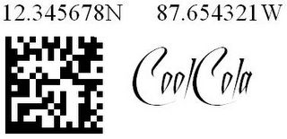
Any/Every Road Sign, Building, Company can have its own co-ordinates printed in Human Readable form and stuck onto it. The sign would also contain a Barcode or Semacode as shown above that indicates the co-ordinates. This will allow a cellphone with a camera to snap the barcode of any building and determine its co-ordinates.
a. Initially this can be taken up by enthusiasts(people who want to show off that they are early technology adopers). They can have such bar coded co-ordinates in front of their houses.
b. The government can mandate the signs on all roadsigns, government buildings, post offices... etc. or maybe even mandate in general.
c. GPS vendors can increase their visibility by encouraging this activity.
Once the general infrastructure becomes available even those who have no access to GPS can find it usable. Remembering a co-ordinate would be just as easy as easy as dealing with telephone numbers. Any Tom Dick and Harry can start using co-ordinates in his address book. Just by even manually scribbling down the co-ordinates on a piece of paper and hunting for an address would be easy. Just keep moving in the direction where the imprinted co-ordinates are closer and closer to the destination one is looking at.
A trivial example could be a guy with a conventional camera phone goes to a place snaps a barcode and SMSes his friend to come to that location. The friend who is driving that way can use his camera phone without GPS to snap a picture of some bar code he encounters to know where he is and to get driving directions.
A guy who just has a good old cell phone phone without GPS can still manually type in the co-ordinates he sees on some building or street sign and get info/driving directions.
The higher one is in the technology chain, the more comfortable the usage of the co-ordinate information would be. But luxury comes for a price.
What the physical imprinting of the co-ordinates and the barcode will do is to make the technology reach maximum number of people. From the Cellphone manufacturer's perspective all this noise about longitudes and latitudes increases the adoption rate of GPS enabled Cell Phones.
I would call the imprinted co-ordinates as the "Poor Man's GPS".
Of course there needs to be common standard adopted for the barcodes across the world, and the software needed to print them out. But these are trivial compared to the benefits.
Addendum
I was googling to see if my article had picked up any attention and to my surprise I landed up on the following site http://jidanni.org/geo/taipower/howto_en.html
There he discusses how TaiPower's convention of naming Electric site poles can be used to determine its co-ordinates. Cool idea. I really appreciate it. He called his idea as the "Poor Man's GPS". Maybe now I should call mine as "The Poor Man's GPS 2.0". maybe 3.0, 4.0, N.0 or 0.0 who knows ;-)
Addendum
Maybe someone needs to create a handheld GPS enabled barcoded-co-ordinate spraying device. Just take it anywhere, press a button and an inkjet nozzle squirts out the co-ordinates onto the object. Maybe the printed image can also have the Name of the advertiser inside it. If you are not able to imagine what I am trying to say, you can check out:
http://www.pdacortex.com/printdreams.htm.
http://www.printdreams.com/inside/rmpt.html
They have a few nice self explanatory pictures there. The only thing that needs to be done is adding a GPS device into it.
FAQ
Q:Does the camera phone need to have a barcode reader?
A:NO, the camera phone just needs software which already exists to convert a picture containing the barcode into coordinates. You can check out the following URL to find out how this works
http://semacode.org
You can check out the following URL to find out which phones support this software.
http://semacode.org/weblog
Q:Do I need to have a cell phone to use this system?
A:No, anyone who can just read numbers and know what North,South,East,West means, can read out the numbers printed along with the barcode and know where he is located.
Q:Why are companies going to sponsor printing of the barcodes?
A:Certain companies such as courier services, pizza outlets, etc., would benefit from increased efficiencies of operations by the uses of such a system in the areas they serve. They could even give a tiny discount for shipping of parcels that have the destination coordinates written correctly on it. As already mentioned they could also use this as a method of brand advertising by imprinting their company logo and/or slogan along with the barcode. Companies ranging from Mobile service providers to Coke and Pepsi can sponsor the printing of the barcodes. Since people would actively look at these, the accompanying advertisement is also registered in their minds.
Q:Does the system require a large initial investment?
A:As already mentioned no new devices are required for reading the coordinates or scanning them. The printing of the barcodes is a one time activity and the price per printed barcode would be negligible and can sponsor itself through advertising.
Q:Is it not easier for me to just search for the addresses on google maps and take a printout than use the coordinates for reaching my destination?
A:Most of the time people do not have access to computers, printers, etc, as these are bulky and fixed assets. The idea here is not to prevent you from using a map but be able to conveniently deal with situations even when you don't have one. You can also use the barcode information to instantly geotag a photo even if you don't have a GPS camera phone.
Q:Is all the noise about such a barcode based system going to increase the number of GPS units or GPS camera phones? or will it have a negative effect?
A:As people see more and more activity around coordinates they will find newer and newer uses for it. Also more people get familiar with the whole concept of Global Positioning which encourages them to buy devices having GPS capabilities.
Q:What about RFID, WiFi hotspots and other such mechanisms?
A:All these can peacefully co exist and complement each other. The barcodes are the cheapest option. So you can have the maximum number of them. They also have the advantage of being usable by those without electronic gadgets. But they require the attention of the user. RFID tags, Bluetooth, WiFi etc, can capture co-ordinates invisibly and are therefore easier to use.
Q:Can I not find my way using just Google Maps?
A: Yes you can. If you have access to a PC or other device that has Google Maps capability and have a printer nearby. Go ahead and take a printout and follow your route. This is not a replacement of Google Maps. In fact you can snap a nearby barcode and land up on that exact spot on Google Maps.
Please Leave your comments here. Tell something discreet. I would prefer clear arguments,suggestions etc. than, "Wow how cool" or "hey that is just a dream"!!!
I was suddenly awakened to the fact that - It will take quite a while before the GPS enabled camera phones become ubiquitous. Till then we will have to live in a world with
1. Users with GPS enabled camera phones.
2. Users with camera phones.
3. Users with cellphones without cameras.
4. Users without even cellphones.
The buzz and adoption of the GPS enabled Camera phones would definitely be maximized if all these segments of users could derive maximum benefit from Longitude, Latitude information using whatever technology they already own.
So here comes the suggestion:
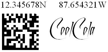
Any/Every Road Sign, Building, Company can have its own co-ordinates printed in Human Readable form and stuck onto it. The sign would also contain a Barcode or Semacode as shown above that indicates the co-ordinates. This will allow a cellphone with a camera to snap the barcode of any building and determine its co-ordinates.
a. Initially this can be taken up by enthusiasts(people who want to show off that they are early technology adopers). They can have such bar coded co-ordinates in front of their houses.
b. The government can mandate the signs on all roadsigns, government buildings, post offices... etc. or maybe even mandate in general.
c. GPS vendors can increase their visibility by encouraging this activity.
Once the general infrastructure becomes available even those who have no access to GPS can find it usable. Remembering a co-ordinate would be just as easy as easy as dealing with telephone numbers. Any Tom Dick and Harry can start using co-ordinates in his address book. Just by even manually scribbling down the co-ordinates on a piece of paper and hunting for an address would be easy. Just keep moving in the direction where the imprinted co-ordinates are closer and closer to the destination one is looking at.
A trivial example could be a guy with a conventional camera phone goes to a place snaps a barcode and SMSes his friend to come to that location. The friend who is driving that way can use his camera phone without GPS to snap a picture of some bar code he encounters to know where he is and to get driving directions.
A guy who just has a good old cell phone phone without GPS can still manually type in the co-ordinates he sees on some building or street sign and get info/driving directions.
The higher one is in the technology chain, the more comfortable the usage of the co-ordinate information would be. But luxury comes for a price.
What the physical imprinting of the co-ordinates and the barcode will do is to make the technology reach maximum number of people. From the Cellphone manufacturer's perspective all this noise about longitudes and latitudes increases the adoption rate of GPS enabled Cell Phones.
I would call the imprinted co-ordinates as the "Poor Man's GPS".
Of course there needs to be common standard adopted for the barcodes across the world, and the software needed to print them out. But these are trivial compared to the benefits.
Addendum
I was googling to see if my article had picked up any attention and to my surprise I landed up on the following site http://jidanni.org/geo/taipower/howto_en.html
There he discusses how TaiPower's convention of naming Electric site poles can be used to determine its co-ordinates. Cool idea. I really appreciate it. He called his idea as the "Poor Man's GPS". Maybe now I should call mine as "The Poor Man's GPS 2.0". maybe 3.0, 4.0, N.0 or 0.0 who knows ;-)
Addendum
Maybe someone needs to create a handheld GPS enabled barcoded-co-ordinate spraying device. Just take it anywhere, press a button and an inkjet nozzle squirts out the co-ordinates onto the object. Maybe the printed image can also have the Name of the advertiser inside it. If you are not able to imagine what I am trying to say, you can check out:
http://www.pdacortex.com/printdreams.htm.
http://www.printdreams.com/inside/rmpt.html
They have a few nice self explanatory pictures there. The only thing that needs to be done is adding a GPS device into it.
FAQ
Q:Does the camera phone need to have a barcode reader?
A:NO, the camera phone just needs software which already exists to convert a picture containing the barcode into coordinates. You can check out the following URL to find out how this works
http://semacode.org
You can check out the following URL to find out which phones support this software.
http://semacode.org/weblog
Q:Do I need to have a cell phone to use this system?
A:No, anyone who can just read numbers and know what North,South,East,West means, can read out the numbers printed along with the barcode and know where he is located.
Q:Why are companies going to sponsor printing of the barcodes?
A:Certain companies such as courier services, pizza outlets, etc., would benefit from increased efficiencies of operations by the uses of such a system in the areas they serve. They could even give a tiny discount for shipping of parcels that have the destination coordinates written correctly on it. As already mentioned they could also use this as a method of brand advertising by imprinting their company logo and/or slogan along with the barcode. Companies ranging from Mobile service providers to Coke and Pepsi can sponsor the printing of the barcodes. Since people would actively look at these, the accompanying advertisement is also registered in their minds.
Q:Does the system require a large initial investment?
A:As already mentioned no new devices are required for reading the coordinates or scanning them. The printing of the barcodes is a one time activity and the price per printed barcode would be negligible and can sponsor itself through advertising.
Q:Is it not easier for me to just search for the addresses on google maps and take a printout than use the coordinates for reaching my destination?
A:Most of the time people do not have access to computers, printers, etc, as these are bulky and fixed assets. The idea here is not to prevent you from using a map but be able to conveniently deal with situations even when you don't have one. You can also use the barcode information to instantly geotag a photo even if you don't have a GPS camera phone.
Q:Is all the noise about such a barcode based system going to increase the number of GPS units or GPS camera phones? or will it have a negative effect?
A:As people see more and more activity around coordinates they will find newer and newer uses for it. Also more people get familiar with the whole concept of Global Positioning which encourages them to buy devices having GPS capabilities.
Q:What about RFID, WiFi hotspots and other such mechanisms?
A:All these can peacefully co exist and complement each other. The barcodes are the cheapest option. So you can have the maximum number of them. They also have the advantage of being usable by those without electronic gadgets. But they require the attention of the user. RFID tags, Bluetooth, WiFi etc, can capture co-ordinates invisibly and are therefore easier to use.
Q:Can I not find my way using just Google Maps?
A: Yes you can. If you have access to a PC or other device that has Google Maps capability and have a printer nearby. Go ahead and take a printout and follow your route. This is not a replacement of Google Maps. In fact you can snap a nearby barcode and land up on that exact spot on Google Maps.
Please Leave your comments here. Tell something discreet. I would prefer clear arguments,suggestions etc. than, "Wow how cool" or "hey that is just a dream"!!!
posted by Unknown at 1:03 AM
![]()


<< Home