Making it easy for the Layman to use the Semacode based "Virtual GPS"
If you are new to this blog please read the earlier post titled "The poor man's GPS"
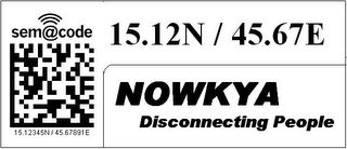
Here is an example which illustrates how one can reach a house or building located at 15.12345N / 45.67891E.

When one is driving on main road or a highway he is not very particular about the insignificant digits of the co-ordinates. Even if we retain just 2 digits after the decimal point we get a resolution of 1.1 Km which is more than enough for getting a sense of one's location.

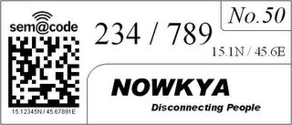
After reaching close to the destination, one can start hunting for a particular house or building in a particular area. The integer parts of the latitude and longitude are extremely unlikely to change and even the first digit after the decimal point changes only once in 11 Kms. Therefore these numbers are printed small adjacent to semacodes on houses. Infact for small cities these numbers can be constant throughout the city. So we now have 3 digits of latitude and 3 digits of longitude left, using which a person can reach a 11m x 11m spot of land. After reaching the spot he can find the house or building using the house/building number mentioned along with the semacode.
When you try to imagine uses for such a system, stop asking yourself where are GPSes being currently used... The current uses of GPS are primarily limited by its cost and nothing else. Once the co-ordinates are available universally, it won't be ten of thousands of users who would use this, but hundreds of millions of people.
Imagine having to cram your brain with hundreds of Chinese names like Quin Qan Xing, Ching Chang Poi etc on a visit to china. The harder part is you have no extra info with these names and you also dont know the local language. If you just misspell due to lack of familiarity of language, you could land up in a totally different place. But the moment you see a Co-ordinate you immediately know how far your destination is from you. How far you are from your hotel etc. Same for a Chinese in the US or Europe. See the previous post about how easy it is to estimate approximate distance from your destination with an average accuracy of about 80 percent without even having to pull out a paper for calculations.
Lasallastrasse does not bring anything to my mind if I go to Europe and Nanjundeshwara Nagar would sound meaningful to an Indian but for an outsider a Nagashettahalli would not bring up any different picture. In such situations co-ordinates are the easiest way to identify current location as well as destination. If co-ordinates are available over the place, one feels more comfortable as he has some idea where he is at any point of time. Especially if you are in place where the native language is different from yours. Even if you just have a low detail map and the map has co-ordinates as well which usually is the case, it becomes extremely easy to deal with navigation and travel.
The moment people know the co-ordinates of their own houses, they can specify it on mails, couriers etc. This would significantly improve reliablity of delivery, which any person would definitely like to have. The postman or courier boy could have a GPS with him, or he too can rely on the co-ordinates available around, in conjunction with your mail address.
Specifying your delivery address on Websites(that really need it)would become much easier too.
Those who want to geotag images can simply snap a semacode and then the actual scenery or object and just MMS it to a site like geobloggers or flickr or some other moblogging site which could geotag the image with the co-ordinate info.
The possibilities are endless, we have just begun to see the tip of the iceberg. This current state of the GeoSpatial Web, is like it was when 640k of RAM was like too much of storage for a PC. As more and more people use co-ordinates for day to day activities, we shall begin to see, unforseen innovations in this area.
Here is an example which illustrates how one can reach a house or building located at 15.12345N / 45.67891E.

When one is driving on main road or a highway he is not very particular about the insignificant digits of the co-ordinates. Even if we retain just 2 digits after the decimal point we get a resolution of 1.1 Km which is more than enough for getting a sense of one's location.

After reaching close to the destination, one can start hunting for a particular house or building in a particular area. The integer parts of the latitude and longitude are extremely unlikely to change and even the first digit after the decimal point changes only once in 11 Kms. Therefore these numbers are printed small adjacent to semacodes on houses. Infact for small cities these numbers can be constant throughout the city. So we now have 3 digits of latitude and 3 digits of longitude left, using which a person can reach a 11m x 11m spot of land. After reaching the spot he can find the house or building using the house/building number mentioned along with the semacode.
When you try to imagine uses for such a system, stop asking yourself where are GPSes being currently used... The current uses of GPS are primarily limited by its cost and nothing else. Once the co-ordinates are available universally, it won't be ten of thousands of users who would use this, but hundreds of millions of people.
Imagine having to cram your brain with hundreds of Chinese names like Quin Qan Xing, Ching Chang Poi etc on a visit to china. The harder part is you have no extra info with these names and you also dont know the local language. If you just misspell due to lack of familiarity of language, you could land up in a totally different place. But the moment you see a Co-ordinate you immediately know how far your destination is from you. How far you are from your hotel etc. Same for a Chinese in the US or Europe. See the previous post about how easy it is to estimate approximate distance from your destination with an average accuracy of about 80 percent without even having to pull out a paper for calculations.
Lasallastrasse does not bring anything to my mind if I go to Europe and Nanjundeshwara Nagar would sound meaningful to an Indian but for an outsider a Nagashettahalli would not bring up any different picture. In such situations co-ordinates are the easiest way to identify current location as well as destination. If co-ordinates are available over the place, one feels more comfortable as he has some idea where he is at any point of time. Especially if you are in place where the native language is different from yours. Even if you just have a low detail map and the map has co-ordinates as well which usually is the case, it becomes extremely easy to deal with navigation and travel.
The moment people know the co-ordinates of their own houses, they can specify it on mails, couriers etc. This would significantly improve reliablity of delivery, which any person would definitely like to have. The postman or courier boy could have a GPS with him, or he too can rely on the co-ordinates available around, in conjunction with your mail address.
Specifying your delivery address on Websites(that really need it)would become much easier too.
Those who want to geotag images can simply snap a semacode and then the actual scenery or object and just MMS it to a site like geobloggers or flickr or some other moblogging site which could geotag the image with the co-ordinate info.
The possibilities are endless, we have just begun to see the tip of the iceberg. This current state of the GeoSpatial Web, is like it was when 640k of RAM was like too much of storage for a PC. As more and more people use co-ordinates for day to day activities, we shall begin to see, unforseen innovations in this area.


<< Home