Tuesday, June 28, 2005

Making it easy for the Layman to use the Semacode based "Virtual GPS"

If you are new to this blog please read the earlier post titled "The poor man's GPS"

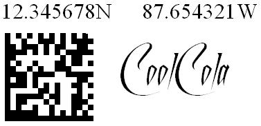
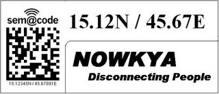
Here is an example which illustrates how one can reach a house or building located at 15.12345N / 45.67891E.


When one is driving on main road or a highway he is not very particular about the insignificant digits of the co-ordinates. Even if we retain just 2 digits after the decimal point we get a resolution of 1.1 Km which is more than enough for getting a sense of one's location.


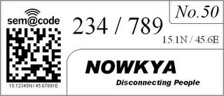
After reaching close to the destination, one can start hunting for a particular house or building in a particular area. The integer parts of the latitude and longitude are extremely unlikely to change and even the first digit after the decimal point changes only once in 11 Kms. Therefore these numbers are printed small adjacent to semacodes on houses. Infact for small cities these numbers can be constant throughout the city. So we now have 3 digits of latitude and 3 digits of longitude left, using which a person can reach a 11m x 11m spot of land. After reaching the spot he can find the house or building using the house/building number mentioned along with the semacode.

When you try to imagine uses for such a system, stop asking yourself where are GPSes being currently used... The current uses of GPS are primarily limited by its cost and nothing else. Once the co-ordinates are available universally, it won't be ten of thousands of users who would use this, but hundreds of millions of people.

Imagine having to cram your brain with hundreds of Chinese names like Quin Qan Xing, Ching Chang Poi etc on a visit to china. The harder part is you have no extra info with these names and you also dont know the local language. If you just misspell due to lack of familiarity of language, you could land up in a totally different place. But the moment you see a Co-ordinate you immediately know how far your destination is from you. How far you are from your hotel etc. Same for a Chinese in the US or Europe. See the previous post about how easy it is to estimate approximate distance from your destination with an average accuracy of about 80 percent without even having to pull out a paper for calculations.

Lasallastrasse does not bring anything to my mind if I go to Europe and Nanjundeshwara Nagar would sound meaningful to an Indian but for an outsider a Nagashettahalli would not bring up any different picture. In such situations co-ordinates are the easiest way to identify current location as well as destination. If co-ordinates are available over the place, one feels more comfortable as he has some idea where he is at any point of time. Especially if you are in place where the native language is different from yours. Even if you just have a low detail map and the map has co-ordinates as well which usually is the case, it becomes extremely easy to deal with navigation and travel.

The moment people know the co-ordinates of their own houses, they can specify it on mails, couriers etc. This would significantly improve reliablity of delivery, which any person would definitely like to have. The postman or courier boy could have a GPS with him, or he too can rely on the co-ordinates available around, in conjunction with your mail address.

Specifying your delivery address on Websites(that really need it)would become much easier too.

Those who want to geotag images can simply snap a semacode and then the actual scenery or object and just MMS it to a site like geobloggers or flickr or some other moblogging site which could geotag the image with the co-ordinate info.

The possibilities are endless, we have just begun to see the tip of the iceberg. This current state of the GeoSpatial Web, is like it was when 640k of RAM was like too much of storage for a PC. As more and more people use co-ordinates for day to day activities, we shall begin to see, unforseen innovations in this area.

Monday, June 27, 2005

How hard is it for the “Common Man” to use the Poor Man’s GPS mentioned earlier?

Many of the readers quickly grasped how the users with a camera phone or with just a cellphone might use the system. However the common question was how will a person without these use these reach their destination? Some even asked if he needs to know pythogoras theorem or distance formula from analytical geometry. So here is my answer.

Latitudes: A degree of latitude always corresponds to about 111 km. So if there is difference of one in the first decimal point of the latitude, it corresponds to a difference of ~10 km. If the difference is 3 then the difference is something like ~30km. If the numbers differ on the second decimal point of the latitude by 5, the difference is like 5 km. On the third, it is like 100m per digit change. On the fourth it is like a 10m change and on the fifth it is like a one meter change.

Longitudes: A degree of longitude corresponds to a distance from 0 to 111 km depending on how far away it is from the equator. For a certain city or town these differences shall be negligible between different parts except for places like the North and south pole which are very sparsely inhabited. We just need to multiply the difference in longitudes with a constant which applies to that city. For cities and places close to the equator, we can treat it just like we trated the latitude, assuming approximately that each digit change in the first decimal place of the longitude meant a 10km difference. Each digit change in the second place meant one km and so on… As you go up you could compute the changes as 3/4, 1/2,1/4th and so on.

That way you don’t have to actually do any serious multiplication division etc. And any way you are never going to the destination through the shortest path or geodesic. So you can coolly add the two numbers you found out earlier i.e the diff b/w longitudes in km and the same for latitudes and just tell yourself roughly how far you are from your destination. You also always know whether you destination lies towards your north or south, east or west. So moving around is more like Golf. First you hit far away and as you keep getting closer to your destination, you start hitting more carefully. It does not need any extra ordinary brilliance to move around the city with some simple heuristics about big barriers like rivers, major highways etc. and some common sense along with the co-ordinates of your target scribbled in your addressbook and co-ordinates imprinted on various objects like mailboxes of houses, power poles etc..

Using Landline Telephone Numbers for GeoLocation.

LandLine telephone numbers are associated with a particular physical address. It can be trivially mapped to a geographical co-ordinate. Once the mapping is available, you just need to know the destination phone number. Just SMS it to a specific number, along with where you are currently located and it can send you back an SMS or MMS telling you how to reach there. In short you can use a fixed landline’s phone number just the way you would use a Long/Lat co-ordinate.

Also once the mapping is available, we can massively automate the process of creation and distribution of the barcodes mentioned in my earlier article titled The Poor Man’s GPS. In some centralised office with a few employees, the barcodes for all subscribers of the telephone network could be printed out by pinpointing the addresses in the telephone directory using Google Maps. These can be delivered to the users along with their telephone bills. That way the human labour is minimized. The users can then stick it next to their mailbox for Example.

Sunday, June 19, 2005

Bringing Global Co-Ordinates Indoors.

As every one knows, GPSes don't work indoors, To fix this we can use some new technology we haven't implemented yet. Possibly using beacon signals, Signals from Cell Phone towers etc. But the incentive to reuse existing technologies is very high. Let me explain a way through which my earlier suggestion of snappable barcoded co-ordinates can be extended to work inside buildings.

If you have not read my previous post titled "The Poor Man's GPS" this post might not make sense to you. That aricle discusses how Camera Phones without GPS capabilities can be used as a "virtual GPS unit" by taking snaps of barcoded co-ordinates imprinted all over the world on all kinds of immovable objects like buildings,doors,lamp posts, road signs etc.

One way to achieve this could be a position sensing device wrt. to a fixed point (maybe using sound, radio signals etc) within the building. Then use GPS to determine some points outside the building for reference. The co-ordinate spraying device I discussed in "The Poor Man's GPS" post could be extended in this manner to be used inside buildings. Remember this is a one time activity. Once the co-ordinates are imprinted, all one needs to do is just use a camera phone to find out the co-ordinates one is at.

Another source of co-ordinates info could be CAD files created by the Architects of those buildings.

Have you heard of photogrammetry? Check out photomodeler.com. In fact they have some very interesting (though a bit dragging for a nerd) videos of creating 3D models from photographs taken from arbitrary directions. The guys at Google are doing something similar by driving thru and creating a 3D model of San Fransisco. The same thing can be done with a building like a hospital, airport, historical site, resort, office building etc. Once you have a 3D model you can determine the co-ordinate of any door knob or speck of dust. If you know the GPS co-ordinate of even a few points(I guess 3) in the building the rest can be trivially determined.

Friday, June 17, 2005

The GeoSpatial Web - RightClick a Photo GoThere!!!

Just imagine if every browser had the following feature :
"Right click on any image(geotagged) in any website and say go there!!!".

On clicking "Go There", the browser would open a new Window and take you to the particular spot on the Map, on GoogleMaps or Geo Bloggers or Some other new service available at that point of time. There you will be able to explore around the map looking for other nearby photos or people or events or shops or statistics or whatever at that location using the co-ordinate information. You can do this because every photograph was taken Somewhere. It has the exact longitude,latitude co-ordinates embedded inside. Wondering what I am speaking about? Read my earlier posts if you are new to geoblogging geo tagging etc...

Once enough geotagged images are available, I guess an xpi on FireFox & a toolbar for IE are enough to achieve the expected results... Maybe even some kludge in Javascript would suffice... But eventually I see it becoming part of standard browzer functionality.

You may look at a National Geographic Photo and decide to go there for your vacation... Before doing that you want to get a feel of the place. So you just right click the photo, say "go there" and poke around to see if the place really suits you. May be you will see a thumbnail of a photo from CNN on the Map about the spread of dengue or Yellow fever in that particular area and postpone your trip.

You might be seeing a photo of the WTC on BBC on the morning of Sept the 11th, and realize that one of your friends could be there. You right click the Image and say go there. You know that this place ought to have too many photos. So to limit your list you choose a time filter which shows you snaps taken between 6.AM and 2PM on the 11th of Sept. You can do this because you not only have the co-ordinates in the photo but also a timestamp. Now you can see pushpins all over the map in that area which would be of photos taken by CNN, BBC, Fox News,Bloggers and a zillion other sources. Maybe you might just spot your friend in one of those photos... You could use that clue to probably get some idea about what happened to him.

I am sure you can imagine billions of such ad-hoc uses... In fact I would say people would use these resources just like you use Google today. Just use your instincts on the spot rather than enlisting/learning all possible uses beforehand.

Remember that the Geo Tagged Photos are "two way transit points to your site".
1.People can come into your site from a map by clicking some thumbnail of your geotagged photo.
2.They can go into the map by right clicking any geotagged image and saying "Go There".

CNN,BBC,Nat Geo, Oprah etc could make it available to
1.Give a richer user experience to visitors in terms of enabling them to explore the backgrounds of photos on their sites.
2.To PULL users exploring the surrounding areas on the Maps into their site.
Bloggers, Wikipedia, Personal Website Owners etc. will make this available out of sheer fascination and the thrill of having done something worthwhile.

Now let us consider videos and movies, each frame has its own longitude, latitude co-ordinates... On any Frame, say right click and go there... Maybe you are watching a blockbuster movie and u get an urge to holiday on a particular island where the action is going on... Just Pause the move and click "Go There". A map opens up showing you hotels in that area, You can ask Google Maps to give you driving instructions to reach there... You can Check out hotels nearby... on and on and on..

Maybe you are watching a documentary about the Eiffel Tower and are curious about how the surrounding places have evolved in the recent years. Just right click and choose go there and have a look at all photos nearby taken at various points in time.

If you are wondering what happens if Photographs are tagged with wrong Co-ordinates, check out my previous post titled "Preventing GeoSpatial Spam - A Solution".

Let me know what you feel about this through your comments...

Thursday, June 16, 2005

Prevention of GeoSpatial SPAM – A Solution!!!

Oreillynet has an article titled: The Geospatial Web: A Call to Action

It lists out 10 action points we need for creating a “Sustainable GeoSpatial Web”. I quote the ninth point from that list -

9. Vigorous, well-funded, productive R&D focused on the prevention of geospatial spam.
Quite a few geobloggers have attempted to put geocoordinates in the head and meta sections of HTML documents. However, this approach hasn't been widely accepted, because pages are not searchable by location. The problem, while still hypothetical, is spatial spam. There's nothing to prohibit spammers from putting multiple locations in the HTML of a single page so that the page shows up in searches for different locations. Based on early, painful experience with meta tag spam, search engines just ignore meta tags altogether. Spatial spam is one problem we can anticipate before it happens. Let's figure out a solution.

If you are wondering what this is all about… I guess you have not heard about the following:
1. maps.google.com and google map hacks.
2. Geo Blogging.
3. The Where 2.0 conference.
4. GPS.
5. GPS Camera Phone.
If the above terms look like Chinese to you, then check out my earlier post titled “The GeoSpatial Web – Backgrounder”.

Every photo on this planet needs to have its longitude and latitude co-ordinates and Time embedded (invisibly as exif data). This allows us to query very specific details in general. For Example: You could ask :
  • Show all Photos taken in Afghanistan between 4 am to 10 am on 15th September 2005.
  • Show all marriage photos of marriages conducted at a particular resort so you glean some hints of how you could plan your own wedding there.
  • Crime statistics on Maps.
  • Pollution sources marked on Maps.
  • The list just goes on… Check out this long list if you want.

GPS camera phones can embed co-ordinates and time into photographs. But users will soon fill in fake co-ordinates to put promotional / advertising material onto the maps. One solution to this problem is to use manual labor to sort out the correctly marked co-ordinates from the false ones. One may use user ratings, wiki like mechanisms etc. However it is still a very hard process especially when you can expect each Camera or Camera Phone owner to be uploading hundreds and thousands of photos.

[[Disclaimer: First let me confess, I have not done an extensive search to confirm if some one has already come up / patented this idea. The hope is that this counts as prior art if I am indeed the first one to come up with it so that no one in the future can patent it. I have also posted this on www.shouldexist.org with the same intention.]]

My suggestion :

A GPS Camera Phone with hardware that “Digitally Signs” photos it takes along with its metadata like co-ordinates and time.

If you are new to the concept of Digital Signatures Please look up my earlier post titled “Backgrounder - Digital Signatures”. Else Please continue reading...

Ok so here is what happens.
  • The camera has one or more Public/Private Key pairs. The private keys are generated and stored in the hardware in such a manner that to get to the keys you will need to rip apart the IC and get the keys. The Public keys are available to the public.
  • Before the cameras are shipped for distribution, the manufacturer (who would be the Certifying Authority CA in this case) vendor issues a Digital Certificate saying that the particular Public Key/Keys correspond to Private keys embedded inside Cameras manufactured by them).
  • The camera captures the GPS, co-ordinates and time and puts it inside the EXIF data. (Note: time can be verified using the GPS subsystem itself. For more details pls check Wikipedia).
  • The camera signs the image with the EXIF data and inserts the signature also into the image as EXIF data.

Whenever a site like GeoBloggers comes across photos which contain co-ordinates that are signed… It can be sure that these photos were taken at the mentioned co-ordinates and time.

How hard is this for the users?
Users do not need to know anything. Just buy a signature enabled GPS camera phone.. Snap and send photo. Nothing more!!!

How hard is it for manufacturers?
As phones are becoming smarter and the usage of https or secure connections increase, the need for cryptographic hardware on phones increases anyway. So in fact this feature won’t cost the Mobile manufacturers much extra except for a change in attitude. Also just look at how affordable RSA security gadgets have become now a days…

How hard is it for flickr, geoblogger etc?
For Flickr or geoblogger the signatures are just EXIF data. Signature verification algorithms/libraries are already available. They just need to hook them up!!!

And here is another hidden benefit free…
Once the infrastructure is in place, you can confirm not only the co-ordinates and time on a photo but also that the photo itself is unaltered and is as seen by the camera.

Does that mean that once the system becomes prevalent, those who have older cameras or camera-phones will not be able to use their devices?
Suppose the geotagged items are displayed on a map, then links to
1. All "camera signed snaps" can be shown with say Blue Push Pins.
2. The ones approved by a moderator can be shown with say Green Push Pins.
3. The ones that have been there for a long time and not removed by the moderator say with Yellow Push Pins.
4. The new ones with Orange Push Pins.
5. Those reported as Spam with Red Push Pins.
The user will have the choice about the type of Links he would like to see.

Do you think there is a trivial way of bypassing the GeoSpatial Spam Prevention Method mentioned here?

Do you think the cost involved would be too high? If so what according to you would be the most expensive aspect of the system? Can u Justify?

Do you think there are easier ways of accomplishing the same or better results? if so what are they?

Looking forward to an intellignt discussion in the comments...

The Poor Man's GPS

I was really impressed by Wade Roush’s comments on his Continuous Computing blog. Check out my earlier post. Actually this blog started life as a comment that I Posted on Wade’s blog.

I was suddenly awakened to the fact that - It will take quite a while before the GPS enabled camera phones become ubiquitous. Till then we will have to live in a world with
1. Users with GPS enabled camera phones.
2. Users with camera phones.
3. Users with cellphones without cameras.
4. Users without even cellphones.

The buzz and adoption of the GPS enabled Camera phones would definitely be maximized if all these segments of users could derive maximum benefit from Longitude, Latitude information using whatever technology they already own.


So here comes the suggestion:
Any/Every Road Sign, Building, Company can have its own co-ordinates printed in Human Readable form and stuck onto it. The sign would also contain a Barcode or Semacode as shown above that indicates the co-ordinates. This will allow a cellphone with a camera to snap the barcode of any building and determine its co-ordinates.
a. Initially this can be taken up by enthusiasts(people who want to show off that they are early technology adopers). They can have such bar coded co-ordinates in front of their houses.
b. The government can mandate the signs on all roadsigns, government buildings, post offices... etc. or maybe even mandate in general.
c. GPS vendors can increase their visibility by encouraging this activity.

Once the general infrastructure becomes available even those who have no access to GPS can find it usable. Remembering a co-ordinate would be just as easy as easy as dealing with telephone numbers. Any Tom Dick and Harry can start using co-ordinates in his address book. Just by even manually scribbling down the co-ordinates on a piece of paper and hunting for an address would be easy. Just keep moving in the direction where the imprinted co-ordinates are closer and closer to the destination one is looking at.

A trivial example could be a guy with a conventional camera phone goes to a place snaps a barcode and SMSes his friend to come to that location. The friend who is driving that way can use his camera phone without GPS to snap a picture of some bar code he encounters to know where he is and to get driving directions.

A guy who just has a good old cell phone phone without GPS can still manually type in the co-ordinates he sees on some building or street sign and get info/driving directions.

The higher one is in the technology chain, the more comfortable the usage of the co-ordinate information would be. But luxury comes for a price.

What the physical imprinting of the co-ordinates and the barcode will do is to make the technology reach maximum number of people. From the Cellphone manufacturer's perspective all this noise about longitudes and latitudes increases the adoption rate of GPS enabled Cell Phones.

I would call the imprinted co-ordinates as the "Poor Man's GPS".

Of course there needs to be common standard adopted for the barcodes across the world, and the software needed to print them out. But these are trivial compared to the benefits.

Addendum
I was googling to see if my article had picked up any attention and to my surprise I landed up on the following site http://jidanni.org/geo/taipower/howto_en.html
There he discusses how TaiPower's convention of naming Electric site poles can be used to determine its co-ordinates. Cool idea. I really appreciate it. He called his idea as the "Poor Man's GPS". Maybe now I should call mine as "The Poor Man's GPS 2.0". maybe 3.0, 4.0, N.0 or 0.0 who knows ;-)

Addendum
Maybe someone needs to create a handheld GPS enabled barcoded-co-ordinate spraying device. Just take it anywhere, press a button and an inkjet nozzle squirts out the co-ordinates onto the object. Maybe the printed image can also have the Name of the advertiser inside it. If you are not able to imagine what I am trying to say, you can check out:

http://www.pdacortex.com/printdreams.htm.

http://www.printdreams.com/inside/rmpt.html

They have a few nice self explanatory pictures there. The only thing that needs to be done is adding a GPS device into it.

FAQ

Q:Does the camera phone need to have a barcode reader?
A:NO, the camera phone just needs software which already exists to convert a picture containing the barcode into coordinates. You can check out the following URL to find out how this works
http://semacode.org
You can check out the following URL to find out which phones support this software.
http://semacode.org/weblog


Q:Do I need to have a cell phone to use this system?
A:No, anyone who can just read numbers and know what North,South,East,West means, can read out the numbers printed along with the barcode and know where he is located.

Q:Why are companies going to sponsor printing of the barcodes?
A:Certain companies such as courier services, pizza outlets, etc., would benefit from increased efficiencies of operations by the uses of such a system in the areas they serve. They could even give a tiny discount for shipping of parcels that have the destination coordinates written correctly on it. As already mentioned they could also use this as a method of brand advertising by imprinting their company logo and/or slogan along with the barcode. Companies ranging from Mobile service providers to Coke and Pepsi can sponsor the printing of the barcodes. Since people would actively look at these, the accompanying advertisement is also registered in their minds.

Q:Does the system require a large initial investment?
A:As already mentioned no new devices are required for reading the coordinates or scanning them. The printing of the barcodes is a one time activity and the price per printed barcode would be negligible and can sponsor itself through advertising.

Q:Is it not easier for me to just search for the addresses on google maps and take a printout than use the coordinates for reaching my destination?
A:Most of the time people do not have access to computers, printers, etc, as these are bulky and fixed assets. The idea here is not to prevent you from using a map but be able to conveniently deal with situations even when you don't have one. You can also use the barcode information to instantly geotag a photo even if you don't have a GPS camera phone.

Q:Is all the noise about such a barcode based system going to increase the number of GPS units or GPS camera phones? or will it have a negative effect?
A:As people see more and more activity around coordinates they will find newer and newer uses for it. Also more people get familiar with the whole concept of Global Positioning which encourages them to buy devices having GPS capabilities.

Q:What about RFID, WiFi hotspots and other such mechanisms?
A:All these can peacefully co exist and complement each other. The barcodes are the cheapest option. So you can have the maximum number of them. They also have the advantage of being usable by those without electronic gadgets. But they require the attention of the user. RFID tags, Bluetooth, WiFi etc, can capture co-ordinates invisibly and are therefore easier to use.

Q:Can I not find my way using just Google Maps?
A: Yes you can. If you have access to a PC or other device that has Google Maps capability and have a printer nearby. Go ahead and take a printout and follow your route. This is not a replacement of Google Maps. In fact you can snap a nearby barcode and land up on that exact spot on Google Maps.

Please Leave your comments here. Tell something discreet. I would prefer clear arguments,suggestions etc. than, "Wow how cool" or "hey that is just a dream"!!!

The Missing Mobile Device: A GPS Camera Phone

Wade Roush of MIT Technology Review says on his Continous Computing Blog

The Missing Mobile Device: A GPS Camera Phone

I completely agree with Wade…

Wondering what is the use for such a device? Are you muttering to yourself… I am not goin to a place where ill get lost…I’ll get one when I go hitch hiking around the planet… So why do I need GPS now? Check out the rest of this blog and the blogs I read!!!

Real life GPS usage is very different from how they are portrayed in movies. Wondering whether your wife can always see a blinking dot showing where you currently are located? Well this ain’t no movie. If you want to let some one know where you are, you can let him/her/them/all know. It is and should be all in *your* hands.

The GPS camera phone makes it possible to automagically attach longitude, latitude data along with time onto your photo. Now imagine if all photos taken by all people about anything ranging from statues to marriages to funerals to meetings and conferences to wars to public demonstrations to government buildings. Everything could form a huge pool that can be looked using Co-ordinates. Wade calls it Geophotocacheing.

I feel *even* expensive GPS enabled cameras could have ushered in a revolution!!! Now that they are going to be cheap it does not matter anyway... What I meant was it should have been common place much earlier. Anyway there was no Google Maps before Feb ;-).

Consider the case of say "National Geographic", "Discovery" ,"CNN", "BBC", ”AXN”, ”Fox”,”Oprah”… Just imagine if all their newer Photos and Videos were geotagged... All the caves and tombs and rivers and deserts and battle zones. All the travelogues and documentaries and what not!!! Imagine the amount of money they pour into even conventional cameras. What are the camera and camcorder manufacturers waiting for??? Geo tagging is no big deal for these guys. Just imagine the flood of geotagged data even if only the Print and TV Reporters just got these devices. Now just add to that bloggers, honeymooners, etc. and the list just keeps growing... Hey guys where are these GPS enabled devices???

If you are wondering why CNN or BBC would geotag their images, check out my Post titled: The GeoSpatial Web - RightClick a Photo GoThere.

Wednesday, June 15, 2005

GeoSpatial Web Backgrounder - EXIF

Basically, Exif file format is the same as JPEG file format. Exif inserts some of image/digicam information data and thumbnail image to JPEG in conformity to JPEG specification. Therefore you can view Exif format image files by JPEG compliant Internet browser/Picture viewer/Photo retouch software etc. as a usual JPEG image files.

The metadata tags defined in the Exif standard cover a broad spectrum including:

  • Date and time information. Digital cameras will record the current date and time and save this in the metadata.
  • Camera settings. This includes static information such as the camera model and make, and information that varies with each image such as orientation, aperture, shutter speed, focal length, metering mode, and film speed information.
  • Location information, which could come from a GPS receiver connected to the camera. As of 2004 only a few cameras support this, though. Some people therefore use a normal receiver to track their movements, and then post-process the images by matching the timestamps in the images with the log from the receiver and can so add the missing information to images.
  • Descriptions and copyright information. Again this is something which is most often done when post-processing the images, as only high-end camera models let the user choose a text for these fields.


Source: http://en.wikipedia.org/wiki/EXIF
EXIF standard: http://park2.wakwak.com/.../exif-e.html

GeoSpatial Web Backgrounder - GPS

The Global Positioning System, usually called GPS (the US military refers to it as NAVSTAR GPS), is a satellite navigation system used for determining one's precise location and providing a highly accurate time reference almost anywhere on Earth or in Earth orbit. It uses an intermediate circular orbit (ICO) satellite constellation of at least 24 satellites.

The GPS system was designed by and is controlled by the United States Department of Defense and can be used by anyone, free of charge. The GPS system is divided into three segments: space, control, and user. The space segment comprises the GPS satellite constellation. The control segment comprises ground stations around the world that are responsible for monitoring the flight paths of the GPS satellites, synchronizing the satellites' onboard atomic clocks, and uploading data for transmission by the satellites. The user segment consists of GPS receivers used for both military and civilian applications. A GPS receiver decodes time signal transmissions from multiple satellites and calculates its position by trilateration.


Source: http://en.wikipedia.org/wiki/GPS

A popular GPS receiver is Garmin

Check out: http://www.garmin.com
Also you might like to check out their GPS enabled PDA running on Palm OS : iQue3600

GeoSpatial Web Backgrounder - Geoblogging

As u know Flickr allows you to share photos and annotate them. Google Maps shows the map with Pushpins etc and can be embedded. So the Guys at geobloggers.com joined the two allowing pictures to be annotated with Geographical co-ordinates.


In fact, Steve has cooked up a fantastic bit of script, assuming the hazy mudge bit in the middle gets to look nicer ;) It streamlines the whole "How do I find my lat/lon" part.

Click here to check it out.
A guy called Mark has created a lovely visual step by step walkthrough of the process of adding GeoTags via this method.


Of course if you have a GPS enabled Camera phone you are in paradise… Almost ;-)

GeoSpatial Web - Where 2.0 Conference

I quote http://www.oreillynet.com/.../geospatialweb.html

Out of this teeming ecosystem, we can see the beginning shapes of a true geospatial web, inhabited by spatially tagged hypermedia as well as digital map geodata. Google Maps is just one more layer among all the invisible cartographic attributes and user annotations on every centimeter of a place and attached to every physical thing, visible and useful, in context, on low-cost, easy-to-use mobile devices. In a recent email, Nat Torkington, organizer of the upcoming Where 2.0 conference, said it this way: "Everything is somewhere. Whether you're talking about assets, people, phone calls, pets, earthquakes, fire sales, bank robberies, or famous gravestones, they all have a location attached. And everything we touch in our lives, from groceries to digital photos, could have a location. From these locations we could learn a lot more about ourselves and build new economies."


The Where 2.0 http://conferences.oreillynet.com/where conference to be held on June 29-30, 2005 at the Westin St. Francis, San Francisco explores how vendors, application developers, and consumer web companies are using GPS, RFID, WLAN, cellular networks, and networked sensors in new ways to solve old business problems.

GeoSpatial Web Backgrounder - Google Map Hacks

This February Google introduced Google Maps and changed the Internet Mapping Experience for ever. It is a Javascript + XML based service that literally allows you to drag the Map around on your screen using your mouse and zoom in and out. If you have a decent net connection you would in-fact not even realize the maps are coming from elsewhere. It also allows showing of high detail Satellite images. You can in fact zoom in and view your Rooftop in many places in the US.

What is more interesting is that you could actually embed the Google Map component on your own web page with minimal effort. Of course if you want to do anything more than playing around... Do not forget to read the terms of service ;-)


Check out the following links at http://stuff.rancidbacon.com and see its source. Also check the corresponding XML and XSL file mentioned in the Javascript...
demo1.html
demo1.xml
geocodeinfo-demo1.xsl etc...
No Rocket science once u know what is expected of u… I know u don’t need soooo much spoon feeding ;-)